|
|
 |
|
|||||||||||||||||||
Snow Water Equivalent Snow Extent |
 |
|||||||||||
Specifications for the Snow Extent product of GlobSnowBased on the discussions at the Requirements Engineering Review (3 February Geneva), the following specifications are proposed for the Snow Extent Product:
o Basic product: Weekly and monthly, with full global coverage, based on medium resolution optical imagery. o Secondary product: Daily. Daily repeat is not possible for global products; in case of optical imagery because of clouds; in case of SAR because of its insensitivity to dry snow (only wet snow can be detected) and because of limitations in data availability and costs. The relevance of such an intermittent product needs to be discussed with the users.
The added value of the GlobSnow SE product will be:
Snow Extent productThe snow extent product will be created using ESA ERS-2 ATSR-2 and Envisat AATSR data. ATSR-2 and AATSR operating onboard of ERS-2 and ENVISAT since 1995 and 2002, respectively, provide a 15 years data set for producing global snow extent maps at a resolution of about 1 km. The spectral characteristics and resolution of ATSR-2 and AATSR are summarized in Table 1. AATSR and ATSR-2 data are available as gridded radiances with 1 km resolution (all bands, nadir and forward looking), stored in the same data format. One full orbit of AATSR-products is about 300 MB (compressed by gzip), one day global AATSR- data set is about 4.2 GB, one year global data set is about 1.5 TB. Table1:
Both
sensors provide VIS and SWIR channels which is especially important for snow /
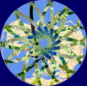
cloud discrimination. The swath width is ca 500 km. As an example Figure 1 shows the coverage of AATSR for the Northern
Hemisphere on 24 May 2008. Figure
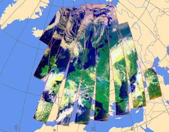
2 and Figure
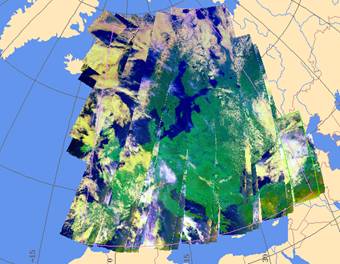
3 show detailed views of the 3 and 6 days coverage of
Figure 1: 1 day coverage of AATSR, Northern Hemisphere, 24 May 2008.
Figure 2: 3
days coverage of AATSR,
Figure 3: 6 days Coverage of AATSR, | ||||||||||||
 |
 |
 |
 |
 |
|||
|
|
 |
 |
| © Finnish Meteorological Institute |