|
|
 |
|
|||||||||||||||||||
Snow Water Equivalent Snow Extent |
 |
OverviewThe European Space Agency (ESA) Data User Element (DUE) GlobSnow Snow Water Equivalent (SWE) product set version 2.0 for the Northern Hemisphere represents information on snow water equivalent retrieved from SMMR, SSM/I, and SSMIS sensors combined with ground-based weather station data from 1979 until present. The SWE production system utilizes SWE retrieval methodology (Pulliainen 2006) complemented with a time-series melt-detection algorithm (Takala et al. 2009), full methodology described in detail in (Takala et al. 2011). The SWE retrieval and melt detection algorithms are combined to produce snow water equivalent maps incorporated with information on the extent of snow cover on coarse resolution (25 x 25km grid cells). The satellite sensors utilized provide data at K- and Ka-bands (19 GHz and 37 GHz respectively) at a spatial resolution of approximately 25 km. The SWE record is produced on a daily, weekly and monthly basis. SWE information is provided for terrestrial non-mountainous regions of Northern Hemisphere between latitudes 35ºN-85ºN, excluding glaciers and Greenland. A semi-empirical snow emission model (Pulliainen et al. 1999) is used for interpreting the passive microwave (radiometer) observations through model inversion to the corresponding SWE estimates. The SWE estimates are complemented with statistically derived accuracy estimate accompanying each SWE estimate (on a pixel level). The SWE products are provided in both NetCDF CF and HDF4-formats: a single file contains the data for a single day; and a single file contains two fields 1) the SWE estimate and 2) an error estimate. The snow water equivalent describes the amount of liquid water in the snow pack that would be formed if the snow pack was completely melted. A thematic accuracy of ~30-35 mm for conditions with less than 150 mm of SWE has been determined for the GlobSnow SWE product (Takala et al. 2011). This is a clear improvement over current alternative datasets when the performance is considered on a continental to hemispherical scale. The GlobSnow SWE data are publicly accessible via (http://www.globsnow.info/swe/) and through a FMI hosted FTP-server; access information to the FTP-server can be acquired through Dr. Kari Luojus (firstname.lastname@fmi.fi). Description of the productThe SWE product is projected to Equal-Area Scalable Earth Grid (EASE-Grid) and provides the whole Northern Hemisphere (lambert's equal-area azimuthal - projection) in a single data field. The nominal resolution of single pixel is 25 km x 25 km and the geometry of the pixels varies. The data field has the size of 721 x 721 (rows x columns). Although the EASE-Grid can represent data almost to the equator the product is limited between latitudes 35° and 85° for physical reasons. There are three products (all in the EASE-Grid) derived for SWE:
In addition to the information on snow water equivalent, the SWE product includes information on the overall extent of snow cover. The information on snow extent is included in the product by utilizing the following coding for the SWE product, SWE values of:
The areas that have been flagged as snow-free or melted are identified using a time-series melt detection approach described in Takala et al. (2009). The areas that are identified as wet snow or have no SWE retrieval, but are identified as snow covered with the time-series melt detection approach are denoted with a SWE value of 0.001mm. The areas that are determined as snow-free or melted by the melt detection approach are denoted with a SWE value of 0mm. All the other areas show a retrieved SWE value (that is in all cases greater than 0.001mm). The weekly (7-days) aggregated product is calculated using sliding window averaging: the SWE estimate for the current day is calculated as a mean of the samples from the previous 6 days and the current day SWE (for each grid cell). The monthly aggregate, a single product for each month, is calculated by determining the mean and the maximum of the weekly SWE samples. The input data for the SWE products are SMMR for 1979-1987, SSM/I for 1987-2009 and SSMIS for 2010-2016 all acquired from NSIDC in EASE-Grid projection with a nominal spatial resolution of 25 km. The weather station synoptic data is acquired from The European Centre for Medium-Range Weather Forecasts (ECMWF). The weather station data applied for the production of the SWE data contain the measured snow depth at the station locations. The SWE product file includes two data fields:
The mountainous areas of Northern Hemisphere are masked out from the SWE product. Topographic information for the masking of mountains (complex terrain) is derived from ETOPO5 (National Geophysical Data, 1988) data, by calculating topography variances within each product grid cell. For the GlobSnow SWE product, an EASE-Grid cell is considered as mountainous if the standard deviation of the elevation within a grid cell is above 200m. SWE estimates for wet snow areas (where retrieval using the radiometer data is not feasible) are determined from the weather station data using kriging interpolation. The methodology used to derive the snow line is described in (Takala et al. 2009). Known issues with the SWE productAvailability of the early SWE data is limited due to two reasons: 1) Availability of ground-based weather station data prior the fall of 1979 2) operation of the SMMR sensor during 1978 to 1987. Although the SMMR data set begins from late October 1978, the ECMWF collected ground-based weather station data record does not contain measurements before fall 1979. Therefore the SWE data set begins in November 1979 (as both microwave radiometer and ground-based weather station data are required to derive accurate SWE estimates). The passive microwave data for 1979 to 1987 are acquired from the Nimbus-7 Scanning Multichannel Microwave Radiometer (SMMR) sensor which was operating every other day and thus can be used to derive the daily SWE time-series for every second day. The weekly aggregated SWE dataset however can be (and is) calculated for every day. The Special Sensor Microwave/Imager (SSM/I) family of sensors have been flown aboard several DMSP-satellites, covering an impressive data record starting from 1987. The SSM/I data are available for every day and the daily SWE products are generated for every day starting from fall 1987. 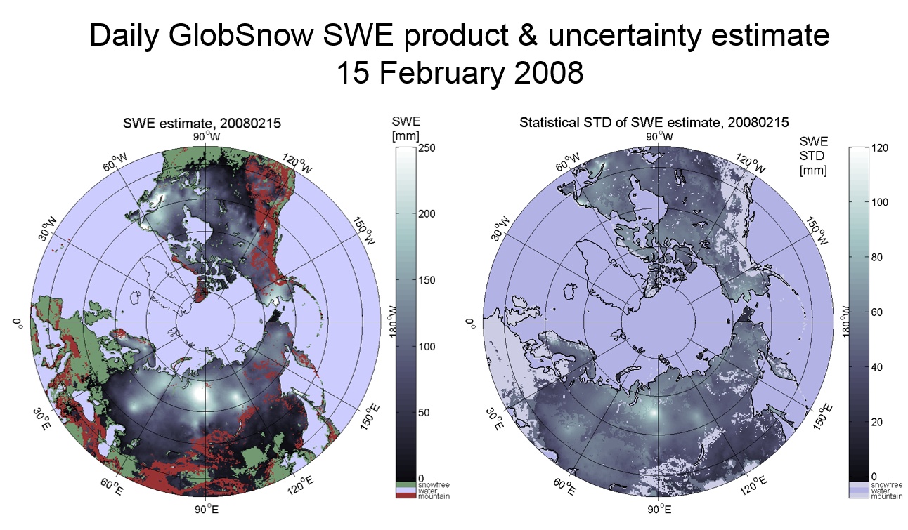 Figure 1 Example of the GlobSnow SWE product for 15 February 2008. REFERENCES:Data Announcement 88-MGG-02, Digital relief of the Surface of the Earth. NOAA, National Geophysical Data Center, Boulder, Colorado, 1988. (ETOPO5)Pulliainen, J., J. Grandell, and M. T. Hallikainen. (1999) HUT Snow Emission Model and its Applicability to Snow Water Equivalent Retrieval. IEEE Transactions on Geoscience and Remote Sensing. 37: 1378-1390. Pulliainen, J., (2006) Mapping of snow water equivalent and snow depth in boreal and sub-arctic zones by assimilating space-borne microwave radiometer data and ground-based observations. Remote Sensing of Environment. 101: 257-269. DOI: 10.1016/j.rse.2006.01.002. Takala, O. M., Pulliainen, J., Metsämäki, S., & Koskinen, J. (2009). Detection of snowmelt using spaceborne microwave radiometer data in Eurasia From 1979 to 2007. IEEE Transactions on Geoscience and Remote Sensing, 47, 2996-3007. Takala, M., Luojus, K., Pulliainen, J., Derksen, C., Lemmetyinen, J., Kärnä, J.-P, Koskinen, J., Bojkov, B., (2011) Estimating northern hemisphere snow water equivalent for climate research through assimilation of spaceborne radiometer data and ground-based measurements, Remote Sensing of Environment, Vol. 115, Issue 12, 15 December 2011, doi: 10.1016/j.rse.2011.08.014. |
 |
 |
 |
 |
 |
|||
|
|
 |
 |
| © Finnish Meteorological Institute |